System Architecture
FracAdapt Complete System Architecture
System Overview
FracAdapt is designed as a cloud-native, scalable predictive maintenance system for military vehicles, integrating terrain complexity with vehicle operational data. The system ingests diverse data sources, processes them through specialized analytical modules, and generates actionable insights for proactive maintenance and operational planning. Its architecture emphasizes modularity, scalability, and robust data security, leveraging AWS services for infrastructure and computational power.

Detailed Phases
Data Ingestion
Raw data, including satellite terrain elevation models (DEMs) and Condition-Based Maintenance (CBM) telemetry from military vehicles, is securely ingested into the system. This phase ensures data integrity and prepares it for initial processing.
Satellite Data: SRTM, ASTER Global DEMs
CBM Data: Vehicle sensor readings, fault codes, operational logs, GPS data
Data Pre-processing & Normalization
Ingested data undergoes cleaning, transformation, and normalization. Terrain data is georeferenced and segmented based on vehicle operational areas. CBM data is timestamp-aligned and filtered to remove anomalies.
Georeferencing & Segmentation
Time-series alignment & filtering
Feature engineering for CBM data
Fractal Analysis Module
The pre-processed terrain elevation data is fed into the fractal analysis module. This module computes the fractal dimension (complexity score) for specific operational areas, quantifying terrain roughness.
Box-counting method for fractal dimension calculation
Complexity score assignment (2.0–3.0 scale)
Spatial indexing of fractal scores
Predictive Modeling (LSTM & GAN)
Integrated LSTM neural networks predict component failure risks based on combined CBM data and terrain fractal scores. A Generative Adversarial Network (GAN) augments the training dataset with synthetic terrain profiles, improving model generalization.
LSTM for time-series prediction
GAN for synthetic data generation
Dynamic model retraining based on new data
Output & Reporting
Predicted failure risks and associated insights are presented through a user-friendly dashboard and accessible via secure API endpoints for integration with existing DoD systems. This includes predictive maintenance alerts and operational recommendations.
Interactive dashboard for visualization
RESTful API for system integration
Automated alert generation
Phase Transitions and Technical Implementation Details
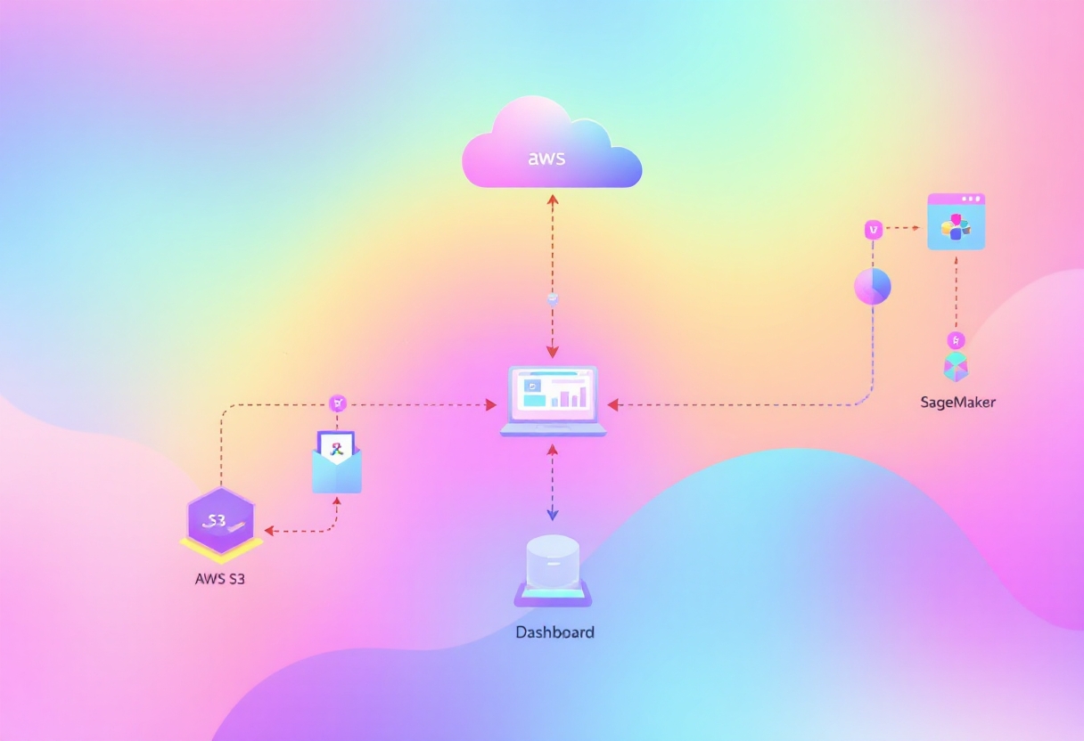
Data transitions seamlessly between phases using asynchronous messaging queues and serverless functions for event-driven processing. This ensures high throughput, low latency, and fault tolerance across the system.

Data Lake: Amazon S3 serves as the central data lake for raw and processed data.
Orchestration: AWS Step Functions orchestrates multi-step data pipelines.
Real-time Processing: AWS Lambda functions handle event-driven triggers for pre-processing and fractal calculations.
Compute: Amazon SageMaker for model training and inference, utilizing GPU instances for LSTM and GAN. Amazon EC2 instances for specialized compute tasks.
API Endpoint Specifications
FracAdapt exposes a set of RESTful API endpoints, secured with AWS IAM and API Gateway, to allow external systems to query predictive maintenance insights and integrate FracAdapt's capabilities. All data returned is in JSON format.
GET /predictive-maintenance/vehicle/{vehicleId} — Retrieves current and predicted failure risks for a specific vehicle.
GET /predictive-maintenance/area/{lat}/{lon} — Provides aggregated risk assessment for vehicles operating in a given geographic area.
GET /terrain-complexity/{lat}/{lon} — Returns the fractal dimension for a specified terrain coordinate.
GET /alerts — Lists active predictive maintenance alerts across the fleet.
Dashboard Components
The FracAdapt dashboard, built using AWS Amplify and React, provides an intuitive interface for visualizing vehicle health, operational risks, and terrain insights. Key components include:
Fleet Overview: Heatmap of vehicle health statuses across operational areas.
Vehicle Detail View: Component-level failure probability, historical data, and maintenance recommendations for individual vehicles.
Terrain Complexity Map: Interactive map displaying fractal dimensions for different regions.
Alerts & Notifications: Real-time display of critical alerts and scheduled maintenance flags.
Reporting & Analytics: Customizable reports on fleet readiness and operational efficiency improvements.
Technical Implementation (AWS Infrastructure)
FracAdapt is built entirely on Amazon Web Services (AWS) to ensure scalability, reliability, and security. The chosen services optimize for cost-efficiency while providing robust computational and storage capabilities.
Data Storage
Amazon S3, Amazon RDS
Scalable object storage for raw data and data lake; Relational database for metadata and application data.
Compute & ML
AWS Lambda, Amazon SageMaker, Amazon EC2
Serverless functions for event-driven tasks; Managed service for ML model training and deployment; Virtual servers for specialized computational tasks.
Networking & Security
Amazon VPC, AWS API Gateway, AWS IAM
Isolated cloud resources; Secure API access; Fine-grained access control and authentication.
Messaging & Orchestration
Amazon SQS, AWS Step Functions
Decoupled microservices communication; Workflow management for complex data pipelines.
Deployment Phases
Complete System Flow Diagrams
The following diagram illustrates the integrated system flow, showcasing how raw data is transformed into actionable intelligence through FracAdapt's core technologies.
LSTM Predicts
GAN Augments
Fractal Score
Real Terrain
How Our Three Technologies Work Together
FRACTAL ANALYSIS
Takes terrain elevation data from satellites
Calculates complexity score (2.0–3.0 fractal dimension)
Simple number that describes "how rough" terrain is
Example: Plains = 2.1, Mountains = 2.8
LSTM NEURAL NETWORKS
Learns from US Army CBM historical data (200+ vehicles)
Discovers patterns: e.g., "When terrain=2.7 AND vehicle_age=40 months → 68% failure risk"
Predicts future component failures for military vehicles based on terrain + vehicle state
Trained on real military vehicle sensor data and fault codes
GENERATIVE AI (GAN)
Generates synthetic terrain profiles that augment the training dataset
Purpose: Enable the LSTM to learn from a more diverse set of terrain-vehicle interactions including edge cases not present in historical data
Enables predictions for new military deployment areas globally
Data Limitations and Methodology
The Innovation
To our knowledge, FracAdapt represents the first systematic approach to combine military vehicle health data (CBM) with quantified terrain complexity analysis methodology. This proof-of-concept demonstrates how terrain-aware predictive maintenance could be implemented for military vehicles when complete location-sensor correlation data becomes available.
Last updated